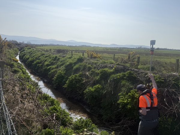
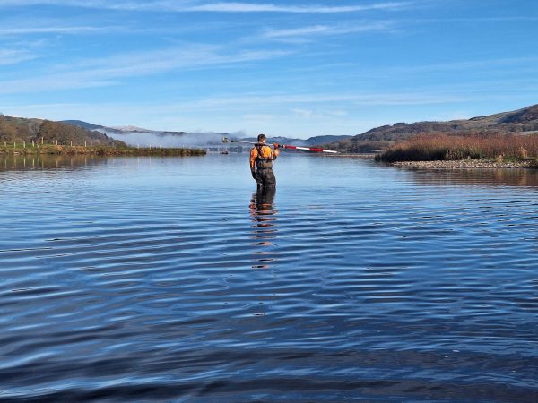
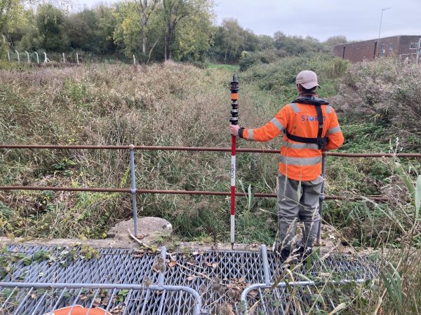
July10

Mike Hopkins - Managing Director volunteered a team of surveyors to help The Salmon & Trout Association measure the 2010 UK Fly Casting Championships at the CLA Game Fair at Ragley Hall in Warwickshire. This presented a big challenge to the surveyors and proved that Storm Geomatics can measure just about anything in any environment under all sorts of pressure. This is the first time a modern approach to measuring the UK fly casting competitions has been put into practice. Mike developed an optical system that quickly pinpoints the fly position on landing and compares it to another coordinated position at the fly casters feet; thus producing the cast distance. For more technical information on this with diagrams and further explanations, please feel free to email Mike and he will send you a fact sheet - mike.hopkins@storm-geomatics.com.
The Salmon & Trout Association are game anglers influencing national decision makers over the management and protection of salmon, trout and sea trout, the conservation of water and the diverse environments upon which all aquatic life depends. They have a very strong scientific panel that back-up all their recommendations and advice with factual evidence. Salmonoids suffer from man-made influences and the Salmon and Trout Association are advisors to the Environment Agency on issues such as Abstraction, diffuse pollution, sedimentation, alien species and global warming. They work hard to improve the habitat of our rivers for aquatic life, which in turn pleases our surveyors as the river is their habitat too!
June10

Surveyors embarked on a large topographical survey in Abingdon to identify the possible use of some open land for a flood storage area (FSA). FSAs are being considered and constructed in many areas local to flooding and are proving to be beneficial in high level events. FSAs are designed to hold water back from areas at risk of flooding at peak flow times, thus avoiding surges of water through towns and villages that can run through residential and commercial properties.
Storm Geomatics have carried out update surveys on various watercourses in the Swindon area as large scale development has altered the courses of rivers and their floodplains. Surveyors have integrated new data into existing models to ensure the system has the best possible information for predicting flood water extents.
A survey team also carried out a storm water drainage survey across 50 manholes on a newly built housing estate in Ripon, North Yorkshire. All levels were captured so drainage engineers could assess the functionality of the network and highlight runs with potential problems.
May10

River modelling has been the core activity of Storm Geomatics from the outset, and there was no change to this in May. Surveyors have captured and created river model data for watercourses in Weston-sub-Edge and Naunton in the Cotswolds, providing the client with critical level data to exacting standards in order to better understand the flooding issues in the villages. The River Pang at Hampstead Norreys was also surveyed this month and the Environment Agency will use the drawings and model data to quantify flood risk and consider flood alleviation schemes for the village.
Storm Geomatics have undertaken some fairly large topographic surveys in Swindon and Abingdon for river asset records and also to look at the feasibility of a flood storage area. As the foliage thickens, surveys around the river become tougher as sight lines diminish. Surveyors covered in insect repellent and sun cream have been slowly hacking though the undergrowth to capture those critical survey points - it’s a good job the summer offers more hours of daylight to compensate!
April10

Surveyors for Storm Geomatics have been out at Batheaston Bridge near Bath this month. The structure is a 400 year toll bridge and the owner wanted an assessment of the bridges stability. Storm Geomatics teamed up with a consulting engineer to provide a detailed scour assessment of the bridge piers. Mike Hopkins (managing director) managed the project which included coring works at the bridge piers to establish pier foundation depth. During the visit surveyors captured data to create a full topographic survey of the entire bridge which provided a base plan to the client for easier asset management. The final part of the package was to provide a flood risk assessment for a “change of use” planning application. All in all, the work went very well and the client now has a a neat package of plans and reports to enhance the management of the bridge.
On the subject of bridges, teams have carried out initial surveys on forty railway bridges throughout central and northern England. These surveys are used to assess the likelihood of scour on the piers and are then graded into risk categories. Higher risk bridges then go into the next phase where a more detailed survey and assessment with recommendations is carried out. This allows the client to make clear decisions on budget allocations and keeps the risk of a bridge collapse to a minimum.
March10

March is traditionally a mad month for our survey teams. As government departments and corporate companies come to the end of their financial year there is a rush to use up budgets and survey work is often a good way to do it. With good organisation and time management Storm Geomatics provide realistic timescales and project schedules to meet our client’s demands. If only it was March every month!
Surveyors have been out surveying six gravel pits near Norwich which have recently been acquired by Anglian Water. Surveyors will perform volume calculations of the pits which will be used to make an assessment on their future use. Surveyors have taken great care to pick up a high density of points ensuring greater volume accuracy, we know how valuable water is and every little helps! The boat team trialled a new electric outboard during the survey in an attempt to reduce carbon emissions and pollution to the water. It performed well and powered the boat along at a good walking pace. It did use three 110Ah marine batteries a day though!
February10

Survey teams have carried out surveys on just about most types of waterways and associated structures this month. With their well kitted out teams and vast experience in watercourse surveys, the client can be assured of a good value survey on time and within budget.
The photo on the right shows a surveyor in action on the Hinksey Stream, he is fastened onto a safety rope whilst surveying the outline of a concrete wing wall. This survey was used to present a deformation survey for the client who needs to ensure the weir is structurally sound.
January 10

Heavy snow brought most of the UK to a stand still in early January but Storm Geomatics braved the elements and moved their schedule around to mobilise on projects with less snow. It was still cold though! One of the diesel cars coughed and spluttered down the road as the -15 degrees C turned the fuel to jelly. In the picture on the right, surveyors are recording levels on the Stanford resevoir spillway where it falls into the River Avon, not on this day though as it was frozen solid!
When the thaw came surveyors went up to Hutton-le-Hole in North Yorkshire where Hutton Beck passes through the typically quaint Yorkshire village. This is part of a series of surveys in villages in Yorkshire where models of the floodplain and river channel are formed for high accuracy flood analysis.
Survey teams also carried out local surveys in Oxfordshire for the Environment Agency and two flood risk assessments (FRAs) in Wales. One of the FRAs in Wales proved the property to be in flood zone 1 and not flood zone 3 as declared by the indicative flood plain map. This will raise the value of the property and reduce insurance premiums.
December 09

Snow came on the shortest day of the year creating further challenges for the surveyors at Storm Geomatics. Site operations continued despite the weather in an effort to keep projects on track. Surveyors were busy collecting model data on a series of fifteen Mills in Essex when the snow started falling. The data will be supplied in Hec-Ras format and will be added into an existing hydraulic model to improve the integrity of its predictions.
Global Gathering the big music festival at Long Marston in Warwickshire asked Storm Geomatics to improve their site plan. Some construction works have been carried out at the site recently and the original survey was updated to improve the spatial planning of the event. A proposal was made to help Global further by staking out the site infrastructure prior to the event which would improve the festival set-up logistics.
Surveyors went back to Bledington in the Cotswolds to carry out a survey on a potential flood storage area. Having carried out previous surveys of the river and its flood plains, engineers have used the data and found a possible solution to alleviate flooding in the village.
Staff at Storm Geomatics would like to thank their clients (old and new) for their support throughout 2009 and wish everyone a happy and prosperous new year.
November 09

Four surveyors from Storm Geomatics Ltd spent the entire night surveying drainage systems and ballast levels on the railway line at either end of the Newport tunnel, South Wales. The track was under a possession from 01:30hrs till 07:00hrs one Sunday morning which allowed surveyors full access to the relevant drainage, which is failing to take heavy rain away from the line. Two teams were mobilised in order to capture all the site data in one session, saving the client time and money. Although the weather was dreadful at times the survey teams completed the work keeping the urgent project on schedule.
Storm Geomatics have teamed up with a local consulting engineer and produced what could be the first batch of many "Statement Of Flood Risk" (SOFR) reports. The reports are carried out on individual properties and investigate in detail the source of the flooding to the property, the resilience of the property to flood water, and provide recommendations that involve amendments to the building and its surroundings to alleviate flooding. There has been a big uptake in this service as individual property owners and businesses brace themselves for some big flood events in the future.
A survey team was up near Whitehaven in Cumbria a day before the recent British rainfall record was broken. The team was working on some dilapidated and remote sea defences which protect the coastal railway line. The survey enabled engineers to quickly and efficiently design reinforcements for the defences so the works could be started without delay. The surveyors made a quick getaway across Cumbria and onto a meeting in North Yorkshire before the record rainfall fell. The thoughts of staff at Storm Geomatics are with those affected by the floods and will continue their work in providing critical information to help alleviate these problems.
Further surveys were carried out in the Cotswolds for the Environment Agency on various flood alleviation schemes. The surveys were used to identify and calculate volumes on Flood Storage Areas (FSA). Storm Geomatics provided volume calculations on the different parcels of land to establish how much flood water could be held in an area behind a bund across the flood plain. This allows water to be controlled and held back at the peak flow of a flood, and then released slowly as the water levels fall, which can be the difference between properties flooding or not.
October 09

Trackside drainage systems in various parts of the north east of England have become inadequate to cope with recent storm water run off. Surveyors have been creating base plan drawings of the drainage systems and their relevant features so engineers can assess and upgrade the system to become 100% efficient.
Flooding on Bedale Beck in North Yorkshire has been a problem to local residents in recent years. Storm Geomatics have surveyed relevant features on the Beck from the confluence with the River Swale to 5km upstream. Surveyors provided a Hec-Ras model to hydraulic engineers who will use it to simulate rainfall and provide schemes to alleviate the flooding problem.
Surveyors were involved in a research and development project for the Environment Agency on the Hinksey Stream, South Hinksey, Oxfordshire. Heavy silt lies on the bed of the stream and surveyors have captured the depth of the silt at 10m spacings over the survey length. This data provides dredging engineers with a base plan to evaluate the benefits of dredging this stream and how much material is likely to be taken out and at what cost. The stream will be monitored closely in the future to assess the cost to benefit ratio of dredging this particular type of watercourse.
September 09

Surveyors have been active on the coastline of North Wales this month working on an urgent project. Sea defences near Llandudno Junction that protect the Crewe to Holyhead railway line were in desperate need of repair. Surveyors worked in split shifts around the tides to deliver valuable base data and condition reports to deliver to the consulting engineers within the agreed deadlines.
Surveyors have also been working locally on the River Isbourne and Beesmoor Brook in and around Winchcombe, Gloucestershire. The rivers were surveyed in order to create a hydraulic model of the system so local consulting engineers can present flood alleviation schemes.
Checks were carried out on the River Ray in Wiltshire for the Environment Agency. The level checks were systematically applied to over 20km of the river to ensure that existing model data for the river, which had come from a variety of different sources, was matching up to one datum.
Otley Weir at Garnetts Mill, West Yorkshire was surveyed for the design of a new fish pass. The weir can be dangerous at medium and high flows and surveyors waited for gauge board levels to fall to 0.400m on the nearby gauge before carrying out the survey. The gauge board readings were acquired from the Environment Agency on a weekly basis.
August 09

Storm Geomatics have captured the interest of the Civil Engineering Surveyor, which is the trade journal of the Institution of Civil Engineering Surveyors or ICES. Storm were asked to provide an article based on their engineering involvement in the high profile Eco House at Barton-on-the-Heath which is to be shown on Channel 4s' Grand Designs program. The article was a setting-out feature in the July/August issue of the magazine. To receive a free PDF of the article, please email us by first clicking on the "Contact" area at the top of this page and then clicking the "email" area. Please make the subject of your email "ICES Article."
Surveyors were asked to complete a volume calculation and contour design for the development of land at a nearby recycling unit. The survey and contour design will help the developer maximise working areas on the site and minimise earth moving fees. An extract of the "Cut/Fill" map can be seen in the picture to the right.
Surveyors have also been busy in the town of Fairford in Gloucestershire. The Environment Agency commisioned Storm Geomatics to capture threshold levels and ground levels adjacent to the River Coln to help assess the risk from flooding to individual properties.
A statement of flood risk was prepared for the change of use of a building in central London. The building which is close to the Imperial War Museum was being converted from a retail unit into a dental practice. Storm Geomatics provided the necessary information to the Environment Agency to make them aware of the changes and any additional flood risk it may cause.
July 09

Jon Teall has won the top award for best student on the two year Survey Association course. Top survey companies from the UK place students on the course to learn the rudiments of surveying. Jon set his sights high on winning the top award from the very outset and has shown huge commitment in achieving his goal. Jon now becomes a surveyor within Storm Geomatics and is on the ladder for professional membership to the ICES. Managing director Mike Hopkins said “This is a very big achievement as the quality of students and coursework is exceptionally high. It has taken a lot of Jon’s own personal time in completing assignments and understanding the mechanics of surveying. We are very pleased to have Jon in our team and thank him very much for his efforts.”
Surveyors have been busy collecting building threshold level data in Aylesbury and Woburn. The project was won on a competitive tender and included control installation using Leica Smartnet.
Surveyors have also carried out a survey of Bedale Beck in North Yorkshire. The survey included 130 cross sections of the Beck and the delivery of an ISIS model, CAD drawings, photographs and a survey report.
Other smaller fluvial watercourse surveys were carried out in Alvechurch, Worcestershire and Great Ayton, North Yorkshire. The latter was noted for its famous “Petch’s Pies” – the Corn Beef Pie was a particular favourite for a surveyor’s lunch!
June 09

Temperatures hit the nineties later on in June and any thoughts of flooding were probably in the back of most peoples minds. However there have been some very heavy outbreaks of rain across the UK which has been a worry for those whose homes were flooded in July 2007.
Work carried on in the hot weather as surveyors battled with undergrowth at a cement works in Rugby. The work was carried out for a flood risk assessment on Sow Brooke which runs through the works.
The base slab for the PassivHaus at Barton-on-the-Heath was completed and the preformed concrete panels that make up the walls were slotted into place. Storm Geomatics were responsible for the setting out of the slab and were pleased (and relieved!) to hear that the last panel went in with 5mm to spare.
Surveyors also carried out additional work at Bourton-on-the-Water, which provided an accurate topographical survey on which to design a new swale around a pinch-point on the Windrush.
Finally a lake survey was carried out for a TSA member company. The purpose of the survey was to ascertain whether the lake was deep enough to install a coiled pipe on the bed which would be used in a heat exchange system.
May 09

Storm Geomatics have completed a local project in the town of Chipping Campden, Gloucestershire. Over 3km of the idealic River Cam and tributaries were surveyed to create a hydraulic model which will help calculate existing channel capacities and highlight any areas with scope to alleviate flooding.
Setting-out work continued on the PassivHaus at Barton-on-the-Heath as the project gets closer to the concrete pour for the base slab in mid-June.
Additional survey was carried out at a major new recycling plant near Ettington in Warwickshire. Levels were taken in adjacent fields to check the new construction doesn’t interfere with flood storage capacities on the flood plains of the nearby brook.
Work has been carried out on a flood plain near Wellington in Herefordshire. The flood plain is interrupted by a railway embankment passing through it. Storm Geomatics surveyors have measured cross sections on the river and produced elevation drawings of the embankment for hydraulic engineers to work with. The engineers will use the data to assess flow capacities through the embankment.
Surveyors and assistants have been on several courses this month. All site staff are now Royal Yacht Association (RYA) Powerboat Level II and RYA First Aid qualified. Staff with Personal Track Safety (PTS) also went on an optional communications course. The course was led by a retired British Army soldier and was useful in improving the survey teams field communications.
April 09

Storm Geomatics were appointed the setting-out engineers for a high profile residential building. The building is to be featured on the Grand Designs television program and is believed to be one of only 10 buildings within the UK to be granted special PPS7 planning permission as a design that is "truly outstanding and ground breaking" according to paragraph 11 of the above policy. The existing barn on the site has been stabilised and the new house is being built underneath it, making it "invisible" to the surrounding countryside, with an open fully-glazed southerly aspect maximising solar gains. Given these credentials the design will result in the first certified PassivHaus zero-carbon eco-house in the UK. Storm Geomatics have the responsibility to set out the column bases, drainage and lower slab. Surveyors are also monitoring any movement in the steelwork that supports the existing barn.
Surveyors carried out the survey of watercourses in Moreton-in-Marsh, Gloucestershire - the nearest loacation to their centrally located office yet! Cotswold District Council has targeted six areas within their control to have feasibility studies carried out for flood alleviation schemes. Surveyors have been concentrating on a ditch which runs around the town, some road drainage ditches and the River Evenlode to the north of the town. The survey information will help the hydraulic engineers to calculate existing watercourse capacities and identify potential areas for improvements.
Surveyors also carried out thirty-eight bridge elevations for Network Rail. The bridges were located throughout the UK and were all railway crossings over watercourses. The drawings will be used to assess the level of scour at the bridge piers and abutments.
March 09

A Woolly Mammoth was seen near Watermead Park in Leicestershire. Surveyors were installing a Environment Agency control station when they saw a full size model of the beast (pictured) which was sculptured on the remains of a real one found in the surrounding gravel pits about 20 years ago.
March has been a tremendously busy month for the company and staff have shown great commitment in meeting deadlines and satisfying client needs. The company has carried out projects for a broad range of clients (existing and new) from individual home owners to bridge painters to consulting engineers and national agencies. All projects have been water based which continues to strengthen the specialist skills which the company promotes.
The end of March gave the company another opportunity to support local charities by sponsoring a team sports event in aid of the Warwickshire Air Ambulance.
February 09

Surveyors ventured into Pork Pie Country (Melton Mowbray) and surveyed Melton Brook. The survey was part of a project to model eight watercourses in the Leicestershire area. The survey team discovered that not only is Melton Mowbray famous for its pork pies, but also its fabulous stilton.
Dispite the wintery conditions Storm Geomatics have successfully surveyed three gauging stations in the Midlands. Full topographic surveys, cross sections and precise levels on critical equipment were carried out. Drawings were delivered in pdf format to make a neat archiving package for each gauging station.
Storm Geomatics have implemented The Survey Association's "Best Practice Guide to Network RTK" and in some cases are being able to reduce survey fees for clients who are happy to use this technology.
January 09

A rare bird from the heron family was spotted whilst surveying on watercourses to the south-west of Oxford. The “bittern”, which is a brown flecked looking heron, was seen flying along a small watercourse by Anthony Pritchard. The location of the sighting was recorded and the Ordnance Survey coordinates were reported to the Environment Agency.
Storm Geomatics were commissioned to survey a watercourse in the Braunstone area of Leicester. Lubbesthorpe Brook has recently been adopted by the Environment Agency and the survey objective was to verify its existing levels and structures. Surveyors had to meet deadlines in mid January so hydraulic engineers could start their river modelling process.
A topographic survey was undertaken on part of the River Evenlode near Charlbury North Oxfordshire. The survey was undertaken on behalf of the fisheries department of the Environment Agency. A full 3D model of the site was provided with contoured drawings and cross sections.
Storm Geomatics have taken on three new employees this month. The move is an attempt to grow the business in line with the increasing demand for specialist water based surveys. Trainees will have the opportunity to extend their new careers within the company and be part of an exciting and developing industry.
December 08

Storm Geomatics have been awarded a contract to survey 50km of watercourses for the Thames Region of the Environment Agency. The contract which is based on tributaries of the River Thames south-east of Lechlade, Oxon was won on a comeptitive tender basis. Surveyors surveyed and delivered approximately half of the project within six weeks of being awarded the contract.
A survey team mobilised on the west coast of Cumbria at Whitehaven to survey 500m of sea defences. The survey was requested to provide base drawings for engineers to design revetment and sea wall refurbishment.
Twenty-two kilometers of river bank levels were surveyed on the Steeping River around Wainfleet in Lincolnshire. Levels were taken at 25m intervals on the crests of the earth banks which encompass the town. Data collected will be used to check the level of flood protection the banks are providing. Fortunately there was time at the end of the last site day to visit the Batemans brewery in Wainfleet and stock up on some "Rosey Nosey" for a well deserved Christmas break!!
November 08

Company Director Anthony Pritchard attended a conference at Manchester United's Old Trafford Football Stadium. The conference revealed best practice guidelines for Network RTK Surveying in Great Britain. Research and testing was carried out by Newcastle University to prove the accuracies of this GPS technology which has been available and developing for nearly five years. The good news was that network RTK GPS when used by the approved methods, is giving consistent results that will fit the tolerances of many specifications. This will reduce survey fees as control stations can be established in seconds, rather than hours. Download the results using the TSA link on this website.
Surveyors have been busy in Heartbeat country. Flooding in a cutting on the Esk Valley Railway Line near Lealholm was the problem. Surveyors mobilised on the project and captured all relevant details regarding drainage and topography for engineers to provide solutions. Surveyors snapped a steam train chugging up through the cutting; I wonder if Greengrass was on board?
Back in the Cotswolds surveyors completed the survey of over three hundred property threshold levels in Moreton-in-Marsh. Also the fisheries department of the Environment Agency used Storm Geomatics to carry out a topographic survey of a weir and pools on the River Windrush. The survey will be used to regenerate the river in the area and hopefully attract more wildlife into its surroundings.
October 08

A signal crayfish was found in Bampton, Oxfordshire. The invasive crayfish was accidentally trodden on by a surveyor whilst taking river bed levels. These crustaceans are becoming more and more prevelant in our watercourses as they push out our native crayfish.
More work was undertaken in the Cotswolds as a result of the floods of July 2007. Surveyors have been capturing additional levels on existing projects as more flood relief options unfold.
Storm Geomatics carried out the survey work for a flood risk assessment (FRA) in Leek, Staffordshire. They were working for a new client who was preparing the FRA for a major building society headquarters. The survey consisted of a number of small watercourses and some small lakes.
Surveyors carried out a flood risk assessment for an individual client at Saxmundham, Suffolk. An existing building on the site is to be demolished.Floor levels for the new building have been ascertained by comparing flood levels provided by the Environment Agency with actual ground levels on site. Storm Geomatics worked with the architect for the project on determining building design and materials in order to provide additional resilience to flooding.
Two hundred-and-seventy eight threshold levels were taken in and around Witney town centre, Oxfordshire. The new field system for threshold data capture is proving to be a very useful survey tool, saving clients time and money. Top of page
September 08

Storm Geomatics took over 5700 levels over 90 hectares using an all terrain vehicle kitted out with Moving RTK GPS. The 15m grid of levels was captured on The North Wyke Research Facility, Okehampton, Devon. Ditch levels were also surveyed on foot using robotic total stations and pole mounted RTK GPS. The survey was part of a project to better understand the drainage situation at the grassland research station.
Surveyors captured position and height data at 30 borehole locations across the City of Birmingham. A GPS network loop was computed across the observed route and information packs for each borehole were delivered. These measurements are part of a project to better assess the ground water levels across the Birmingham area.
Heavy rains caused devestating floods in Morpeth and the surrounding area. Surveyors mobilised quickly to capture levels in order to ascertain the peak flood data. Lessons can be learnt from real flood events and data about the event is useful to calibrate existing river models. Top of page
August 08

A very busy month for Storm Geomatics. Surveyors carried out the survey work for an assessment on flooding in Bledington, Gloucestershire. The Environment Agency brief was to survey two reaches of different watercourses, a number of threshold levels and provide a topographic survey of an area that could potentially provide water storage. A broad range of survey techniques were used to collect the data from traditional spirit levelling to static GPS. The survey was delivered on time and within budget.
A team also carried out additional work on the salmon weir in Ballina, Ireland. Originally the structure had been surveyed in winter, where water levels had been too high to access bed levels in the individual bays. Surveyors re-mobilised when the water levels were at summer lows, and captured the required information. Surveyors were able to keep costs down by travelling over with a budget airline, and optimising working times with the flight schedules.
Four areas on the westcoast mainline railway were closed while survey teams captured drainage information and topographic surveys in areas that suffered from flash flooding. Teams worked against the clock through the night during "possessions" of the railway in order to get the job done safely within a certain timeframe.Top of page
July 08

Storm Geomatics launch their new website. Whilst retaining a few of the characteristics of the previous website, Storm Geomatics have created a much faster and more efficient information tool. Keep up to date with the monthly news page; find out what services they have to offer, how they do things and who the people are behind the business. All this can be done quickly and simply using the new navigation menus. Thanks to Dom at Syster for all his efforts and input into making this happen.
Meanwhile...survey teams have been working on a project titled "Farming Floodplains for the Future". This is a pilot study funded by DEFRA which is looking at the possibility of creating water storage areas on a couple of river catchments in the Staffordshire area. Storm Geomatics were asked to survey nineteen different areas providing river cross sections, topographic surveys and accurately record the levels of various gauging sites. The scheme is looking into the feasibility of flooding farmland to hold surging water back, and then releasing it again at a rate the river channel can cope with. If successful, this strategy could be used in many parts of the UK.
Surveyors have also carried out survey work on watercourses in Witney and Adderbury in Oxfordshire, and Ilkley in West Yorkshire.Top of page
June 08

Survey teams mobilized on a project to capture property threshold levels in the town of Abingdon, Oxfordshire. One thousand three hundred property threshold levels were surveyed using digital levels and data loggers. The client specified that 12 items of data for each property were to be collected and presented in a spreadsheet that contained address point data. Storm Geomatics have developed a data capture system that moves from field to finish seamlessly, thus providing a cost effective and time saving solution.
Surveyors travelled to Copgrove Hall nr. Harrogate to capture details of the dam wall that retains water for the lake in front of the main house. Details of the control structures, crest levels, and falls from the dam wall were supplied to engineers working on the project.
Storm Geomatics carried out a flood risk assessment (FRA) for a development site in Warwickshire. The site was both surveyed and assessed for flooding by the company. The FRA was submitted to the Environment Agency and accepted. This is now the second FRA the company has undertaken.Top of page
May 08

Surveyors found themselves across the Irish Sea in County Roscommon, Ireland. Cross sections were surveyed on six watercourses in and around Roscommon town, ISIS models were then created of each watercourse. The river models were used to calculate river channel capacities as part of a review of the town's storm and foul water systems.
Another survey team headed east to Great Yarmouth where a topographical survey was carried out on a maintenance depot for a major oil industry supplier. Floor plans of the workshops were also measured. The plans were drawn on a plane grid but centred and rotated to Ordnance Survey grid. This was done to give the client an accurate location of the site in relation to the new port in Great Yarmouth, whilst avoiding using a scale factor which can complicate engineering drawings.
Two small surveys for Flood Risk Assessments were carried out in the north of the country, one on a hotel and one through a village.Top of page
April 08

A survey of the River Bourn in Ashdon was carried out for a hydraulic engineering company. The survey included the data capture of forty cross sections and a number of threshold levels in the area. Flood plain levels were also captured and supplied in ISIS format with the channel data.
A check survey was carried out on a recently surveyed river in the Hartlepool area. These surveys are carried out to give the client confidence in the data they are working with, as more often than not, centimeters can make a big difference to flood forecasting. A schedule of checks were designed around the client's budget.
More railway structures were surveyed this month as an extension to Storm's existing contract. All the additional bridge surveys were large bridges and viaducts which Storm surveyed with their 300m range lasers.
Storm Geomatics sponsored a local team sports event early in July, and also sponsored an event which raised £4000 for a local junior and infant school.Top of page
March 08

Storm Geomatics were awarded a contract to survey the elevations of forty-two railway bridges that passed over watercourses. The bridge locations were spread from London to Carlisle and were requested to be tied into Ordnance Datum. The project is part of a scheme to improve flood warnings for the Network Rail infrastructure.
A flood risk assessment survey was carried out on Pendlebury Brook, St Helens, Merseyside. The project included the survey of cross sections along the Brook, details of the pumping station, flood plain levels and over one hundred threshold levels. The project was completed on time and within budget.
A grid of levels was surveyed over the grounds of the George Hotel in Chollerford, Northumberland. Levels were surveyed to Ordnance grid and datum and also compared to Environment Agency Control. This information was used by modellers to assess the risk of flooding to the hotel.Top of page
Feb 08

Survey teams mobilised on projects in Norwich, Barrowden in Rutland, and Bourton on the Water in Gloucestershire.
In Norwich, a fifty acre brown field site was levelled with two GPS RTK rovers in order to calculate a flood risk assessment for the site.
Storm Geomatics carried out a feasibility study on a mill pond restoration project at Barrowden. The original channel to the Mill pond has been filled in, and has left the pond stagnant. Surveyors worked out a route to take water off the nearby River Welland, and working with hydraulic engineers, provided an outline scheme and costing to bring fresh water back to the pond.
Storm Geomatics won a contract from the Environment Agency Thames Region to survey the flood stricken Bourton on the Water. Surveyors gathered information on the flood event that hit Bourton on 20th July last year, finding out flood peak levels, existing building threshold levels, and direction of flows. Residents and business owners were also interviewed to get feedback on the sequence of events.Top of page
Jan 08

Storm Geomatics were awarded the contract to survey a complex network of drains, watercourses and ditches near Doncaster, South Yorkshire. Up to twenty-five hydraulic models will eventually be constructed and be interactive with each other allowing engineers to have a better understanding of the flooding issues in the area. The job to date has been noted for its blackthorn bushes and its problems with security.
Surveyors also embarked on a survey in a small village in Lincolnshire. The survey brief was to survey approximately thirty cross sections to be presented as a Hec-Ras and ISIS model, with a number of threshold levels and road levels also requested. A flood alleviation scheme is being designed for the village.Top of page