Wild Trout Restoration Through Precision River Surveying
The Background
- Date
- April 2025
- Client
- The Wild Trout Trust
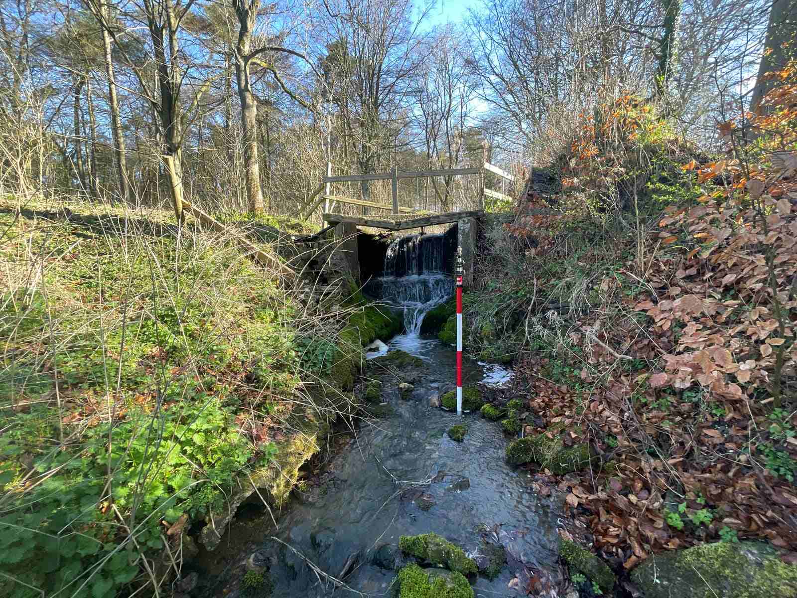
The Wild Trout Trust commissioned Storm Geomatics to conduct a detailed topographic river survey along a 1.3km stretch of a key wild trout watercourse. Known for its native trout population, the river has suffered from silt accumulation and man-made barriers, such as a weir, that restrict natural fish movement—particularly downstream migration vital for breeding.
Understanding the river’s current physical condition is the first step towards improving habitat complexity and restoring ecological function. With accurate, high-resolution geospatial data, the Wild Trout Trust can now design effective interventions to support fish passage, enhance biodiversity, and reconnect natural river processes.
The Challenge
The survey site included a mix of woodland terrain and open riverbanks, presenting a unique set of challenges. Heavy vegetation and tree cover reduced GNSS visibility, requiring multiple total station setups in woodland sections and slowing data capture.
To maintain survey accuracy and efficiency, the Storm Geomatics team—led by experienced surveyor Josh Humphriss and assisted by Trainee Surveyor Harry Sampson used a hybrid approach:
- A Trimble S5 total station for hard detail and complex visibility zones.
- A Trimble R12i GNSS receiver for soft detail in open areas, speeding up the process wherever possible.
The channel survey was conducted at 10m intervals, reduced to 5m in meandering sections, with special attention given to:
- Areas of silt build-up to assess impact on wild trout spawning.
- All structures (e.g., the weir), where detailed cross sections were completed to inform design decisions for fish passage improvements.
Despite slow progress through dense woodland, the team caught up on time in more open areas, ensuring comprehensive data coverage.
The Results
Storm Geomatics delivered a full suite of outputs that empower the Wild Trout Trust to move forward confidently with their restoration plans:
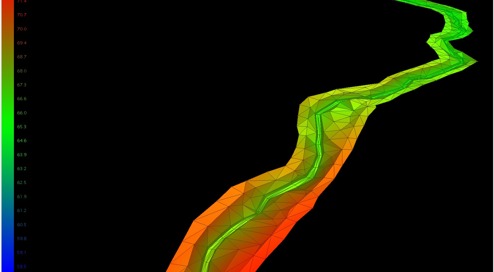
- A 2.5D TIN model for data visualisation.
- Full topographic drawings in DWG and PDF formats.
- Detailed cross sections in DWG, Flood Modeller Pro, HEC-RAS, and XYZ formats.
- A cross-section location plan to aid spatial understanding.
This dataset serves as the “point zero” baseline, enabling accurate assessment of current conditions and supporting long-term monitoring of ecological improvements. The information will directly influence the future design of fish-friendly structures, guide silt management, and foster conditions that allow wild trout populations to thrive.
This project showcases how high-accuracy geospatial surveys underpin effective river restoration.
By working closely with the Wild Trout Trust, Storm Geomatics has provided the critical data needed to remove barriers to fish movement, improve riverbed habitat, and reconnect natural flow regimes—all vital to boosting wild trout populations and revitalising the river ecosystem.


Recent News

Biodiversity Gains Delivered with Data

Geospatial Data Powers Asset Management
