
Afon Hirnant – Thinking Outside the Box
The Background
- Date
- April 2019
- Client
- Leading specialists in environmental engineering and management
One of Storms regular customers had been commissioned to design a fish pass at Pont Y Ceunant on the Afon Hirnant and develop a hydraulic model to assess flood risk of the proposed options.
Storm Geomatics was tasked with surveying the difficult cascade beneath a bridge to supply geospatial data for engineers to make the best decisions on the fish pass design.
About the Client
The client is an environmental, engineering and risk group committed to exceptional client service helping to improve the environment, business and infrastructure. They are a one of Europe’s leading specialists in environmental engineering and environmental management with a strong track record of major studies for national governments and international bodies.
Our client’s lead hydro ecologist made the following comment on completion of the project.
“The level of communication provided by the Storm site team was excellent and facilitated decision making to ensure all deliverables were gathered at what was a very challenging site. Thanks Storm!”
Their Challenge
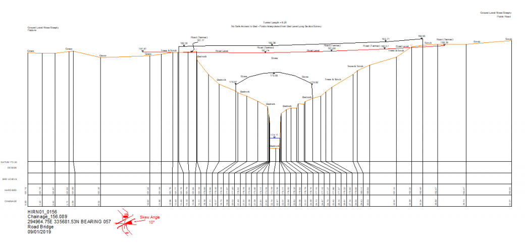
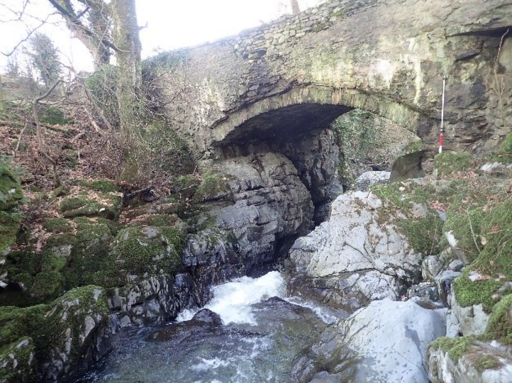
The Afon Hirnant is a plane bed river in the reach of interest and flows between the abutments of the B4403 Road Bridge located in a steep gully. Upstream of the bridge, the gully is initially very steep but rapidly shallows (laterally and longitudinally) on both banks.
Downstream of the road bridge, the Hirnant is significantly confined laterally by steep outcropping bedrock, with banks rising to approximately 8-10m above bed level. The channel is also steep longitudinally in this section, with bedrock sills creating cascade features.
An existing 3D scan was taken by a different company at a time when the channel had been drained down however the bed levels of the deep pools were still missing which were needed to undertake accurate flood model scenarios and then design a suitable fish pass.
The client required 12 cross sections (including the bridge faces), a primary flow centerline of bed levels (60m upstream & downstream of the bridge) and also all trees over 0.15m trunk diameter within certain areas. Data was to be delivered in 3D Cad drawings, HecRas and Flood Modeller formats.
Our Solution
Owing to our extensive experience of this type of project we were happy to proceed without a pre-site visit. The client passed on a contact who was able to supply us with daily river level reports as mobilising at the lowest river levels and in good weather was going to be vital. Our team waited several weeks for the right opportunity in the weather and reported this on a weekly basis to the client. Although the project was under a tight timeframe is was more important the correct information was gathered.
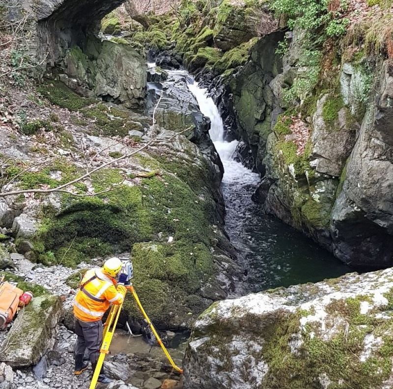
An experienced team of 2 surveyors attended the site during a settled period of weather with low river levels. The team completed a full recce of the site on arrival and after lengthy discussions wrote out a detailed Dynamic Risk Assessment (DRA). The survey team traversed into different predetermined locations from where survey detail was captured utilising conventional surveying techniques. Progress was reported to the client twice a day and the survey team continued to survey all the detail which could be accessed in a conventional manner of wading and scrambling over the rocks. Additional PPE of canoe helmets and gloves were worn throughout along with the normal 150n Life Jackets.
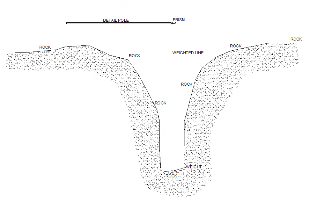
After 1.5 days of work the survey team had several short reaches of bed levels to be surveyed which were inaccessible but vital to the project. These areas were within the narrow gorges immediately downstream of a drop in head of water. The depth of water was also in excess of 2.5m and heavily aerated which would mean a buoyancy aid would be less effective.
The Storm team had to think outside the box and went through previously used methods – a remote controlled boat with echo sounder but this wouldn’t work in the aerated water, they thought about wearing a dry suit and swimming up to these areas but this was too dangerous as there were too many unknowns beneath the surface. They considered additional personnel and being suspended off ropes but again too many unknowns. Eventually the team had the idea to suspend a leaded line from the end of the 4.65m detail pole which was being held horizontally across the channel. The Total Station could be setup downstream and used to ensure the line was vertical before taking the measurement.
Results
A complete data set was surveyed, processed and delivered all within 6 days of mobilisation for this difficult project. Accurate & timely reporting to the client was undertaken to enable him to schedule engineers and make early informed decisions.
While this method used to survey the inaccessible areas was not quite as accurate as the teams modern survey methods it proved acceptable for the project while minimising risks to the survey team.
Recent News

Biodiversity Gains Delivered with Data

Geospatial Data Powers Asset Management
