Redefining River Intelligence – The River Digital Twin®
Across the UK, asset managers are being challenged to deliver more. More resilience, more accuracy, more environmental accountability, more value for customers. Yet much of the infrastructure, modelling workflows, and environmental assessment still depends on datasets that were never designed for today’s climate complexity or regulatory pressure.
Storm Geomatics holds the trademark for the River Digital Twin® (RDT®), a modular geospatial representation of a river with optional high end visualisation. RDT® marks a step‑change in how asset managers, engineers and ecologists understand, measure, and respond to river‑related risk, bringing geospatial survey‑grade data and ecological insight together in a single, authoritative digital asset.
A Digital Foundation Built With Centimetre Accuracy
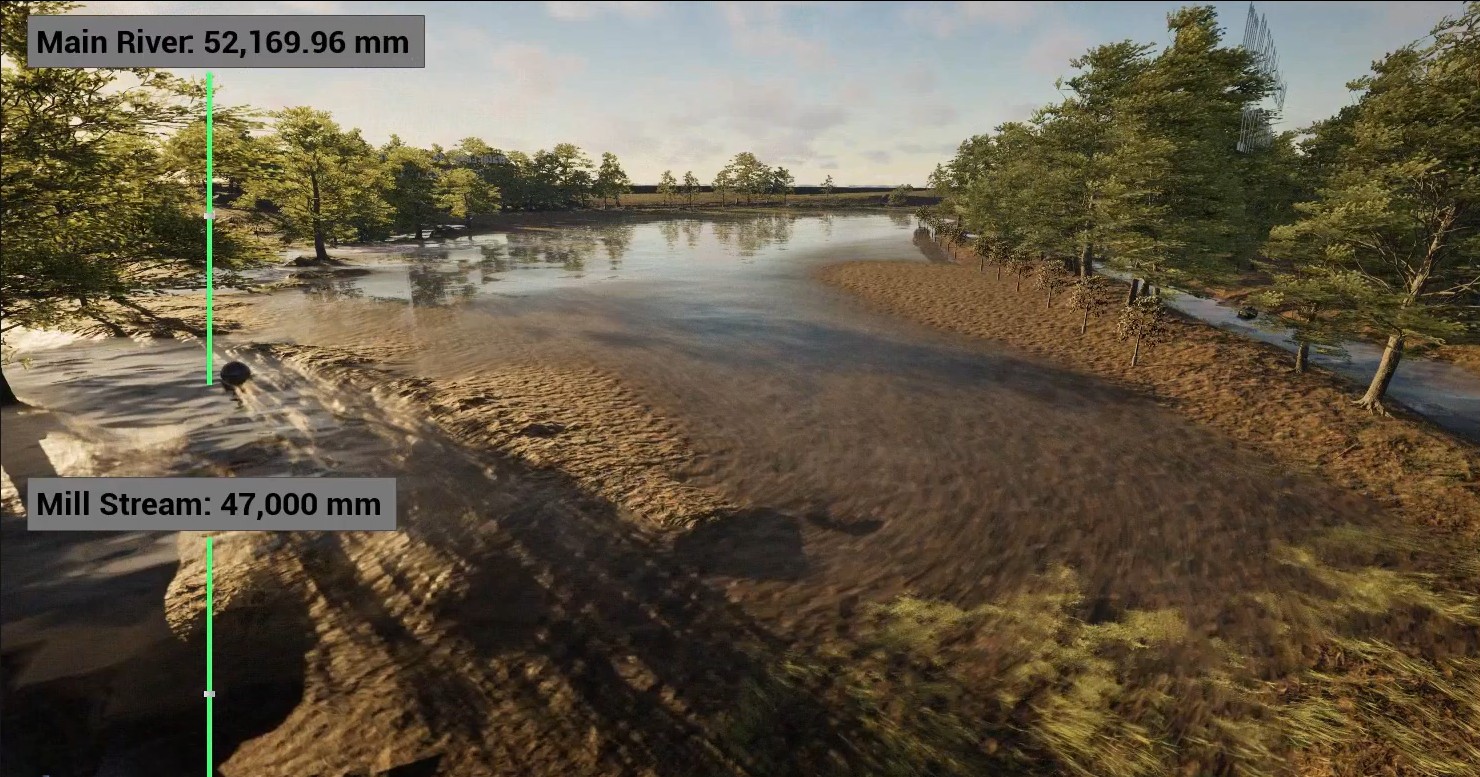
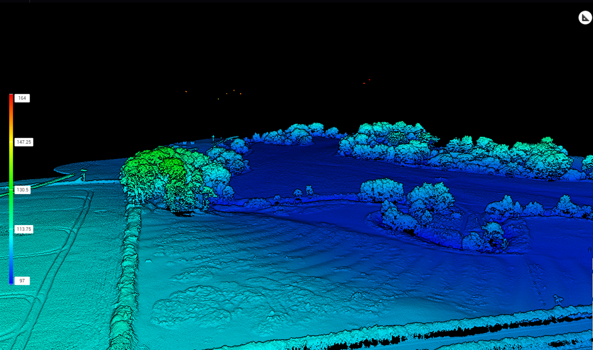
Traditional LiDAR and legacy DEMs offer only partial coverage or coarse representation of river channels. For hydraulic modellers, asset managers and flood risk consultants, that means uncertainty; the enemy of confident decision‑making. The River Digital Twin® overcomes this by providing: centimetre‑accurate 3D data of channels, banks, floodplains and structures. Full integration of hydrographic, topographic and remote‑sensing sensors, capturing what’s above and below the water surface. The result being a complete, consistent baseline for modelling, design and operational assessments. This level of precision significantly reduces the guesswork typically involved in representing berms, embankments, low‑flow channels, cut-fill calculations or engineered interventions in hydraulic models.
A Four-Stage Modular, Integrated System
The River Digital Twin® is a four stage process that forms a modular integrated system, where the client can choose delivery of any of the modular pieces. The first modular part which forms the baseline for the whole system is the The High‑Resolution Point Cloud and is the subject for discussion in this article.
The High Resolution Point Cloud
A High‑Resolution Point Cloud River Digital Twin® solves this with a unified georeferenced asset that can feed:
- 1D/2D/3D hydraulic models
- BIM environments
- GIS systems
- Asset management tools
- Condition assessments
- Capital programme development
It becomes a strategic dataset, delivering measurable efficiencies by reducing site revisits, minimising rework and enabling faster cross‑team collaboration.
By using high resolution point cloud data above and below the water ensures that critical data is captured and doesn’t “miss the grid” as is often the case on publicly available 1m lidar data.
From Reactive to Predictive River Management
For teams facing tighter performance commitments, the RDT® offers a clear operational advantage. With the ability to:
- conduct virtual inspections,
- run scenario planning,
- compare change detection across survey cycles,
- and evaluate asset deterioration or geomorphic shifts,
- move from reactive strategy to a more preventative action plan
Where Engineering Meets Ecology
What’s unique about Storm Geomatics’ approach is that ecological intelligence is designed into the dataset.
The high‑resolution point cloud enables:
- Mapping of riparian vegetation and canopy structure
- Identification of erosion and deposition zones
- Assessment of habitat niches and ecological corridors
- Baselines for long‑term ecological monitoring
This dual‑value perspective of engineering certainty + ecological insight supports stake holders in achieving both regulatory compliance and biodiversity uplift goals simultaneously.
Unlocking Better Flood Modelling, By Design
Every modeller knows that the quality of a hydraulic model is limited by the quality of the geospatial data underpinning it. A rough or inconsistent baseline leads to increased calibration time, instability, and reduced trust in results.
The High‑Resolution Point Cloud River Digital Twin® solves this by providing:
- Seamless opportunity to extract hydraulic model source data along the channel length
- Channel‑form precision
- Full floodplain geometry and early detection of flow paths and spill points
- Correct representation of control structures in the full context of the river and floodplain
This leads to:
- better convergence and stability in 1D/2D/3D models
- fewer site visits and reduced calibration requirements
- lower risk of rework or failed designs
- higher confidence when communicating decision
The High‑Resolution Point Cloud River Digital Twin® is the first step in Storm Geomatics’ modular integrated system. Begin with this certainty and everything built on top becomes stronger from flood forecasting to starting conversations around investment planning or ecological enhancement.
The next article in this series, will explore the DTM River Digital Twin®. The second stage of Storm Geomatics’ modular integrated system. We’ll look at how raw point cloud data evolves into a powerful modelling engine, why structured breaklines matter, and how a truly hydrologically correct DTM changes what you can model, measure and achieve.