GeoRiver® Software

Storm Geomatics have exciting news about their GeoRiver® software – having recently taken full ownership of the river model data preparation software, investment and progress was the order of the month during March. As Storm go full steam ahead with new development into GeoRiver’s capabilities the recruitment of a dedicated software engineer is now complete. Storm welcomed Nethra Viswanathan to the team in late March.
Nethra is a Software Engineer by profession with over 8 years of IT experience, particularly in software development, testing and deployment. After graduation from Shiv Nadar University in India Nethra was placed in Cognizant Technology Solutions. It was a roller-coaster learning experience during her 4.5-year term at the firm as a software developer, where she was able to prove her talent in .Net and SQL Server technologies with secondary focus on HTML and CSS technologies for website building. She was offered different projects requiring a wide range of skillsets which included development of[nbsp] custom functionalities for a life sciences tool which tested pharmaceutical drugs for Oracle America (USA), development and deployment of insurance software products for ACE Insurance Company (USA), migration of database and windows server for a group of European web applications, technology migration from ColdFusion to ASP.Net MVC for a set of European web applications as well as maintenance of the developed products. Nethra then began a four-year period with AstraZeneca India Private Ltd. She was given the responsibility of development and eventually management of a data publishing application called Resource Allocation Central, the main objective of which was data published in different formats for different applications through MuleSoft middleware program.
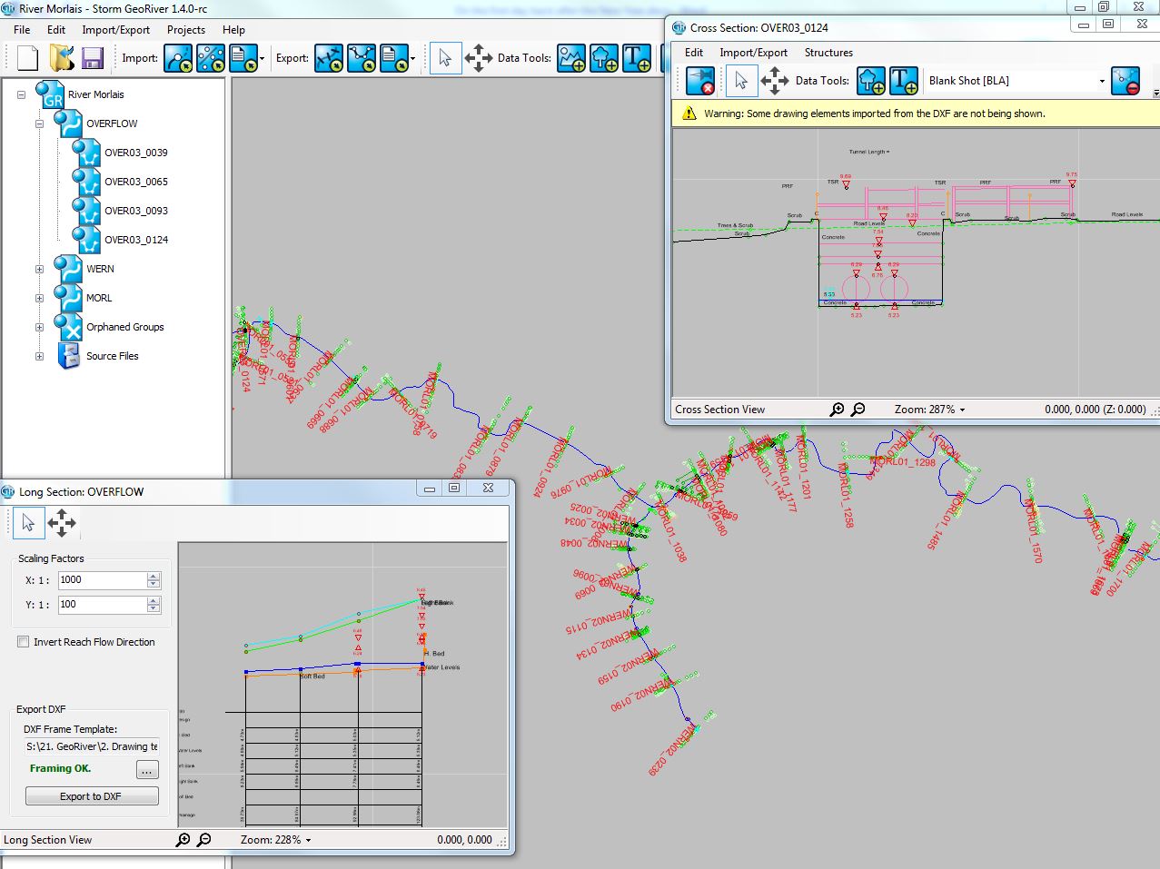
The conception of GeoRiver® was July 2010 and was derived from a gap in the market for a specialist river channel processing software that was fit for purpose, with an aim to create high end river model data preparation. In short, the specialist surveying team at Storm needed a software that would close the gap between survey deliverables and working river models.
GeoRiver® has been designed for two types of user; firstly, the river surveyor who captures vast amounts of position and height data within a river channel and flood plain. Secondly, the hydraulic engineer who uses the data to create a model of the watercourse and simulate its behaviour, thus creating flood defence solutions. With the aim to create a more consolidated automation process to reduce manual input from both the surveyors and hydraulic engineer and less handling of the data the process greatly reduces and provides cleaner, and more accurate data within any hydraulic modelling project. This allows surveyors to process data to Environment Agency standard deliverables including the feature rich format EACSD. In addition, hydraulic engineers can prepare and export structure information into third party modelling software HEC-RAS, TUFLOW, EACSD and Flood Modeller Pro formats, as well as DXF files to represent the river in CAD drawings.
GeoRiver® is an affordable and flexible solution to increasing the productivity of both a surveying practice and engineering practice. Being a cloud licenced software ensures for a low cost, high productivity solution. The licences can be purchased annually or on a 30-day option being ideal for stand alone river projects.
Anthony Pritchard (Director at Storm Geomatics) heads up the GeoRiver® team and is available to give training and support. However, as the interest grows for GeoRiver® please do keep checking Storm’s social media channels for more exciting developments. You really cannot afford not to!


Other News
What’s Driving Our Success in Surveys & Leadership?
Surveying Through the Seasons
